|
Some street names simply cry out for
an explanation. Others quietly hide their origins behind a
name that seems to need no explanation. The streets below are
some that have aroused my curiosity in nearly three decades of
driving around the valley.
Presidential and Numbered Streets
THE PRESIDENTIAL
STREETS
North to South |
| President |
# |
Term |
| Theodore Roosevelt |
26 |
1901-1909 |
| James Abram Garfield |
20 |
1881 |
| William McKinley |
25 |
1897-1901 |
| Franklin Pierce |
14 |
1853-1857 |
| Millard Fillmore |
13 |
1850-1853 |
| Zachary Taylor |
12 |
1849-1850 |
| James Knox Polk |
11 |
1845-1849 |
| Martin Van Buren |
8 |
1837-1841 |
| James Monroe |
5 |
1817-1825 |
| John Adams |
2 |
1797-1801 |
| George Washington |
1 |
1789-1797 |
| Thomas Jefferson |
3 |
1801-1809 |
| James Madison |
4 |
1809-1817 |
| Andrew Jackson |
7 |
1829-1837 |
| William Henry Harrison |
9 |
1841 |
| James Buchanan |
15 |
1857-1861 |
| Abraham Lincoln |
16 |
1861-1865 |
| Ulysses Simpson Grant |
18 |
1869-1877 |
| Omitted
Presidents |
| John Quincy Adams |
6 |
1825-1829 |
| John Tyler |
10 |
1841-1845 |
| Andrew Johnson |
17 |
1865-1869 |
| Rutherford Birchard Hayes |
19 |
1877-1881 |
| Chester Alan Arthur |
21 |
1881-1885 |
| Grover Cleveland |
22 |
1885-1889 |
| Benjamin Harrison |
23 |
1889-1893 |
| Grover Cleveland |
24 |
1893-1897 |
The early layout of Phoenix was a
simple grid, destined to prove that nothing is quite as simple as it
seems. The major streets running east-west were named for the
U.S. Presidents, with Washington in the middle. Subsequent
presidents gave their names to alternating streets first to the
north, then the south in order of office. Adams became the
first street to the north of Washington, Jefferson the first south,
and so on. Indian names were used, more or less, for
north-south streets: Cocopah, Yuma, Papago, Mojave, Cortez,
Montezuma, Maricopa, Pinal, Arivipai, Tonto, Apache.
This scheme of street names began to fall apart from the
beginning. Poor John Quincy Adams had to share a street with
his father. Madison and Monroe were swapped from the locations
that the rotation would have given them. Tyler, Johnson,
Hayes, and Cleveland were forgotten completely. If Chester A.
Arthur was thought of at all, he was surely an afterthought since
tiny Arthur Street runs north-south between Central & 7th
Street. After Roosevelt, the presidential street name idea was
abandoned.
The Indian names for north-south streets faired even worse.
They were dropped in favor of numbers, ascending in both directions
from Central Avenue (originally Centre Street) Avenues to the west,
Streets to the east.
Not all numbered avenues got their names at the same time.
27 north-south streets across the valley were "laterals"
that ran a long a series of farming canals one mile apart.
Until the 1940's when the county gave 27th Avenue its present name,
it was called Lateral 14. (Hayden Road was Lateral 3 until
that time.)
Roads to Institutions
The Bethany Home Road led,
not surprisingly, to the Bethany Home, way outside the city near
what is now 15th Avenue. The "home" was tuberculosis
sanitarium operated by a religious organization in the early 1900's.
The namesake of the home is an ancient town near Jerusalem.
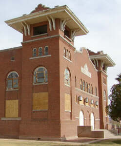 |
| The old school site is now Steele
Indian School Park, but three school buildings remain. This is
Memorial Hall, built in 1922. 2-02. |
Sanitariums were the mainstay for tuberculosis treatment from the
mid 1800's until after 1944 when the antibiotic streptomycin was
first administered to patients. The valley's warm, dry climate
made the valley a prime location for sanitariums. So many
tuberculosis patients stayed in white tents outside Scottsdale that
it became know as the "White City."
Cactus Road is supposedly
named after another TB camp where tents and shacks of suffers were
situated in the early 1900's.
There really was an Indian School at
Indian School Road and Central Avenue from 1891 until 1990.
The boarding school for Indians was one of many across the country
operated by the federal government in an attempt to mainstream them
into white culture. The theory described by an early journalist was,
"It is better to educate the Indian people than to kill
them."
Thunderbird Road ran by
Thunderbird Field Number One at a private flying school around the
time of World War II.
Streets Honoring Persons
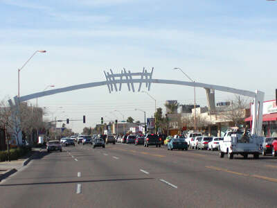 |
| In the 1950's east McDowell
Road between 16th and 20th Streets was such a burgeoning
business area that it became known as "The Miracle
Mile." Over the next four decades the business
climate cooled as commerce moved to shopping centers.
The East McDowell Civic Association sought to revitalize the
area, adopting the theme, "Relive the Miracle."
The strange white painted steel arch, know as the
McDowell Gateway, was commissioned by the city to further this
theme at a cost of $47,500. It was dedicated 1991, with
the hope that it would spur development of the area.
1-02. |
McDowell Road shares its name
with Fort McDowell, the McDowell Mountain Range, McDowell Mountain,
and McDowell Peak. The McDowell in question is Civil War
General Irwin McDowell (1818-1885). A graduate of West Point,
McDowell was in command of Union troops when they were routed at the
Battle of Bull Run. His career survived and he was twice
appointed to command of the department of the Pacific. He
reportedly never visited Arizona, and is interred in the National
Cemetery on the Presidio Military Reservation, San Francisco.
Greenway Road owes its name
to mining magnate General John Campbell Greenway (1872-1926).
An engineering graduate from Yale, and Rough Rider, he was
commissioned as a brigadier general for service on the front line in
France during World War I. Greenway came to Arizona in 1910 to
manage Bisbee mines owned by the Calumet and Arizona Company.
He negotiated the purchase of the Ajo mines, and by developed a
leaching process which he patented and locating a water supply,
turned the area into a profitable mining community.
In 1925 Greenway turned his attention to supplying water to
Arizona by damming the Colorado River in the Grand Canyon.
While attempting to obtain congressional backing, he had a gall
bladder attack, and died following surgery. He was survived by
Isabella S. Greenway whom he had married only two years earlier.
Born in 1886, she had been a old flame of Greenway, but married one
of his best friends who had also been a Rough Rider. She came
west with her first husband for treatment of his tuberculosis.
Two years after his death, she and the General were married.
Isabella Greenway took over management of her deceased husband's
substantial business interests. A bridesmaid at the marriage
of her childhood friend Eleanor to Franklin D. Roosevelt, she gave
the seconding speech to his presidential nomination at the 1932
Democratic National Convention. In 1935, she became the first
woman from Arizona to be elected to Congress. In Tucson, she
opened both the famous Arizona Inn and a birth control clinic in
spite of the Catholic Church's objections to the latter. She
died in Tucson in 1953.
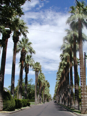 |
| Why do you suppose they named it Palm
Lane? Between 1st and 3rd Streets. 7-01 |
Sidney
Preston Osborn (1884-1948) was the state's 11th governor--7th if
you don't count repeats, or 29th if you count repeats, territorial
governors, and the one who died before taking office. There
may never have been another governor more suited to the office or
with a greater public appeal. In his sixth grade school books,
he wrote "Sidney P. Osborn, Governor of Arizona." He
was the first governor to be elected to four consecutive terms,
serving from 1941 through 1948. His death in office from Lou
Gehrig's Disease, evoked a great outpouring of public sympathy.
It would be no surprise that a sympathetic city would name a street
after the popular governor.
Osborn Road was not named after Governor Osborn.
At the time the street was named, Sidney was a mere teen, and
although he was one of Phoenix Union High's first football stars, it
is unlikely that he had yet done anything to warrant having a street
named after him. The road in question ran by the south edge of
the Osborn family farm, near Central, and had been homesteaded by a
relative of Sidney's, John Preston Osborn, in the late 1870's.
The street became know as Osborn Road around the time of John
Osborn's death in 1900 at the age of 84.
Shea Boulevard and Bell
Road were named after James A. Shea and Harvey Bell. Shea
and Bell were two farmers getting by with well water for irrigation.
They saw more potential for Paradise Valley if an old irrigation
idea were resurrected.
In the 1890's the Rio Verde Canal Company promoted a canal west
from the Verde River, along the base of the McDowell Mountains, and
on to Union Hills which would make that area a "Paradise
Valley." The company drilled a tunnel at Horseshoe Dam
and dug about twenty miles of canals before the venture failed
around 1901.
Fifteen years later Shea and Bell organized the Paradise Verde
Irrigation District. The district took on the Salt Water Users
Association in a battle over the valley's water which lasted nearly
twenty years. In 1934, the Secretary of the Interior ruled in
favor of the other group. Paradise Valley remained a dry
vision until after World War II when developers saw uses that did
not require irrigation.
Broadway Road was not named
after New York's famous street, nor was it especially wide.
Its name comes from Noah Broadway who owned much land in the area
now known as south Phoenix.
Borrowed Names
Grand Avenue was borrowed
from Fresno, California. In 1887 developers from that city
were inspired to create a quick, easy route cutting diagonally from
downtown Phoenix to lure settlers to the west side. Really!
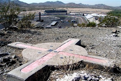 |
| Gila and Salt River Baseline
and Meridian. It might not mean much to most people,
but the Gila and Salt River Baseline and Meridian is the point
from which all property locations are measured in southern
Arizona. Phoenix International Raceway sits just west of
the hill where the monument is located. 10-03. |
Practical Names
The original main survey line of the
valley started from a point atop a small butte east of what is now
the Phoenix International Raceway. The rest of the valley was
measured from a line extending east and west of that point, called
"the Salt River and Gila Baseline and Meridian."
Fortunately for sign makers, the name adopted for the road following
that line was shortened to Baseline Road.
|
