| Sitgreaves Pass Location: On the 1926 alignment of
Route 66; 24 miles west of Kingman; 4.4 miles east of Oatman. |
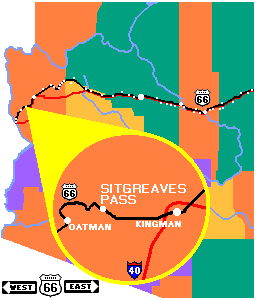 |
| Clickable Map. The original 1926
alignment of Route 66 cuts through the Black Mountains east of
Kingman. Interstate 40, the 1952 alignment and the Santa Fe
railroad bypass the mountains by heading south. |
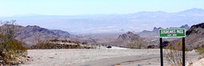
Captain Lorenzo Sitgreaves. Route 66
rises to a peak of 3,550 feet between Kingman and Oatman as it breaches
the Black Mountains. The pass through that mountain range was named
for Captain Lorenzo Sitgreaves. With a small crew of topographers,
artists and naturalists and a 50 infantryman escort, he left the Zuni
Pueblo in northwest New Mexico in 1851. His instructions, prompted
by the possibility of a war with the Mormon settlements in Utah, were to
explore the Zuni and Colorado rivers and evaluate their
navigability. About a decade later, the pass was the site of a
massacre of emigrants by Hualpai and Mohave Indians.
Backing up the mountain. When Route 66 came into existence
on November 11, 1926, not all cars could speed up the mountain through the
pass. The most widely sold vehicle of the time was Ford's Model T
which was produced from 1909 to 1927. The Model T, like other
vehicles of the era, lacked a pump to bring the gasoline from the gas tank
to the engine. Gravity was quite adequate to bring the fuel to the
engine unless the tank was low and the vehicle was traveling up an
incline. The solution to this problem was to back up the steep and
winding mountain road. Visitors heading east on Route 66 can view a
Model T at the garage beside the general store in Hackberry.
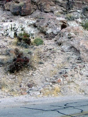 |
| There are 35 stone steps leading up from the roadway
to Shaffer Fish Bowl Spring. 1-04. |
Enterprise on the mountain. A wide spot on the Oatman side
of the peak and to the south mark an old business site and a fine
viewpoint. On the Kingman side and to the north (pictured above)
another wide spot was the location of The Summit ice cream store.
The only thing remaining from the store are a few iron railings.
| Shaffer Fish Bowl Spring Location: 0.8 miles east of
Sitgreaves Pass; 2.1 miles west of Ed's Camp; 23.2 miles west of
Kingman's Powerhouse Route 66 Museum. |
Shaffer Fish Bowl Spring. Less than
a mile east of the pass the alert motorist will spot a flight of 35 stone
steps rising above the hill-ward side of the roadway. At the top of
the flight is one of the more unusual mostly natural, albeit small,
features of old Route 66. Just a few hundred feet from the highest
point of this section of Route 66, natural spring seeps out of a clump of
rocks overlooking the highway.
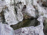 |
| The bowl at the bottom of the spring. 1-04. |
Many years ago someone--most likely named Shaffer--fashioned a basin
about the size of a bath tub out of stones in the area and a little
mortar. Two books that we used to guide us along the road mentioned the
fish bowl but noted the lack of fish. When we were there, two small
goldfish were happily darting around in the fish bowl. While Shaffer
Fish Bowl Spring might be overlooked by the motorist, there was evidence
on the steps that it was not overlooked by wild burros in the area.
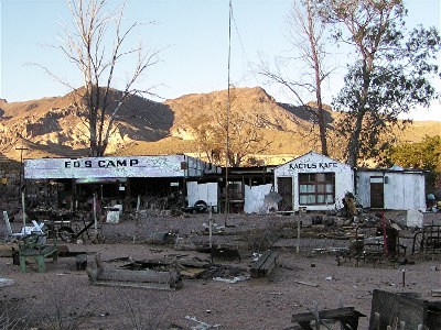 |
| The old gas station and the Kactus Kafe are still
standing at Ed's Camp, as are a few cabins. 1-04. |
| Ed's Camp Location: 2.9 miles east of Sitgreaves
Pass; 2.1 miles east of Shaffer's Fish Bowl Spring;1.2 miles west of
Cool Springs Camp; 21.1 miles west of Kingman's Powerhouse Route 66
Museum. |
A prospector sets up camp. Ed
Edgerton was the last of the old time prospectors in Mojave County.
He set up camp along Route 66 (20.9 miles west of Kingman; 3.1 miles east
of Sitgreaves Pass), and eventually began catering to the motorists with
the Kactus Kafe, a gas station, and cabins.
Ed's Camp is not hard to find. On the rocky side of the hill
directly across Route 66 from the camp, large white letters spelling
"ED'S CAMP" remain. There are a few homes in the area, and
someone appears to have taken up residence behind the old camp facilities.
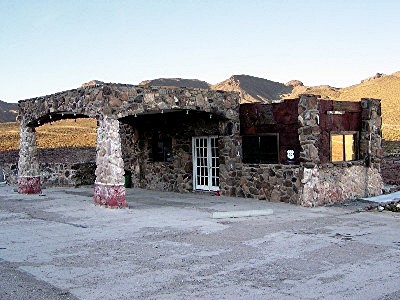 |
| The Cool Springs gas station is rising out of the
dust and debris. Until reconstruction was begun, only the
foundation and the posts, which appear lighter in the picture,
remained. 1-04. |
| Cool Springs Camp Location: 5 miles east of
Sitgreaves Pass; 1.2 miles east of Ed's Camp; 19.9 miles west of
Kingman's Powerhouse Route 66 Museum. |
Cool Springs Camp. Cool Springs
Camp gave early westward bound Route 66 motorists a welcome break before
they tackled the treacherous winding ascent through the Black
Mountains. Built in the 1926, its amenities included a cafe, garage,
a Mobil Oil gas station and tourist cabins.
As with the other businesses catering to Route 66 motorists along the
original alignment east of Kingman, the tourist bubble burst when the
road's alignment was changed in 1952. Cool Springs was converted to
a poultry operation called "The Chicken Ranch." After a
fire, that enterprise was also abandoned.
From ruin to reconstruction to fiery explosion. Time and
vandals took their toll. The walls remaining after the fire
toppled. About the only feature visible to the motorist passing
along old Route 66 were the two posts supporting the gas station's
portico. As Cool Springs was well along the path of turning to
rubble, it experienced a rebirth and destruction Hollywood style.
In the 1992 movie, Universal Soldier, Luc Deveraux (Jean-Claude
Van Damme) is an American soldier murdered in Vietnam by his deranged
commanding officer, Sgt. Andrew Scott (Dolph Lundgren). Luc is
reanimated by the U.S. Army to fight again as a super warrior. When
his memory returns, Luc deserts and heads across the desert southwest with
Scott in hot pursuit. The film crew recreated an old time desert
service station around the Cool Springs ruins. In true action film
style, the station meets a explosive fiery end as the antagonists battle
it out. Cool Springs was not the only community to experience
Universal Soldier mayhem. Other locations used for the feature film
included Ashfork, Cottonwood, Prescott, Grand Canyon, Kingman, Hoover Dam,
Boulder City and Los Angeles.
Restoration begins! Chicago real estate agent Ned
Leuchtner and his wife Michelle purchased the Cool Springs Camp in
2002. They began a slow reconstruction project and planned to
eventually locate to the desert. By 2004, there was again a
recognizable building that could have housed a service station and cafe
with the promise of more coming.
|